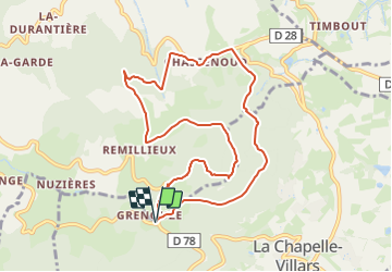
![](/images/other/stat-length.png)
![Trail On foot La Chapelle-Villars - Col de Grenouze - col de Chassenoud - mont Monnet - 9,7 km - 358 m de dénivelé - 3h30 - Photo](https://media.geolcdn.com/t/1900/400/ext.pjpeg?maxdim=2&url=https%3A%2F%2Fstatic1.geolcdn.com%2Fsiteimages%2Fupload%2Ffiles%2F1545311037marcheuse_200dpi.jpg)
Col de Grenouze - col de Chassenoud - mont Monnet - 9,7 km - 358 m de dénivelé - 3h30
Clubléorando
User
![Length](/images/other/stat-length.png)
![Max alt](https://static1.geolcdn.com/siteimages/upload/files/1508320355ic_sort_altitude_max_24dp.png)
![Uphill gradient](https://static1.geolcdn.com/siteimages/upload/files/1508320355ic_sort_den_pos_24dp.png)
![Km-Effort](/images/other/stat-length.png)
![Min alt](https://static1.geolcdn.com/siteimages/upload/files/1508320355ic_sort_altitude_min_24dp.png)
![Downhill gradient](https://static1.geolcdn.com/siteimages/upload/files/1508320355ic_sort_den_neg_24dp.png)
![Boucle](https://static1.geolcdn.com/siteimages/upload/files/16400158638029165_repeat_loop_refresh_sync_direction_icon.png)
![On foot](https://static1.geolcdn.com/sitytour/trail-icons/100.png)
3h30
Difficulty : Medium
![Scan this QR Code to open this trail in the SityTrail application](https://capi.geolives.com/qq0zvz2zws4bq2lad0pu/sitytour/trails/3591063/qr.png?size=200)
FREE GPS app for hiking
About
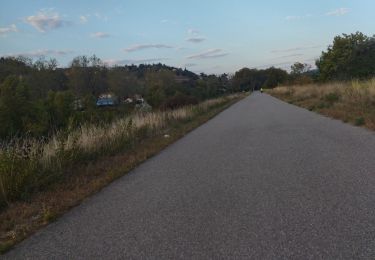
Trail On foot of 9.7 km to be discovered at Auvergne-Rhône-Alpes, Loire, La Chapelle-Villars. This trail is proposed by Clubléorando.
Description
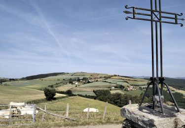
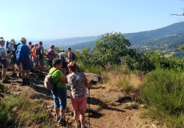
Balade en boucle au départ de l'aire de picnic du col de Grenouze. Prendre le chemin direction nord jusqu'à la côte 654 puis descendre la combe Chavanne par le sentier à droite jusqu'au col de Chassenoud. Traverser le village de Chassenoud puis prendre un sentier à gauche qui permet de traverser le ru de Lota puis reprendre un sentier à gauche qui mène à la croix de Longes et au hameau de Remillieux. Prendre le sentier à gauche qui mène jusqu'à la côte 685 puis un nouveau sentier à droite qui monte en arc de cercle jusqu'au mont Monnet, sa chapelle et sa vierge. Passer à gauche de l'antenne et redescendre le sentier jusqu'à la côte 621. Prendre à gauche la route qui remonte jusqu'au col de Grenouze
Positioning
Comments
Trails nearby
![Trail Walking Chuyer - Autour du mont Ministre - Photo](https://media.geolcdn.com/t/375/260/ext.jpg?maxdim=2&url=https%3A%2F%2Fstatic1.geolcdn.com%2Fsiteimages%2Fupload%2Ffiles%2F1553511878bg_sport_marche.png)
![Walking Walking](https://static1.geolcdn.com/sitytour/trail-icons/101.png)
Walking
![](/images/other/stat-length.png)
![](https://static1.geolcdn.com/siteimages/upload/files/16400158638029165_repeat_loop_refresh_sync_direction_icon.png)
![Trail Walking Longes - 1 septembre 2022 longes - Photo](https://media.geolcdn.com/t/375/260/b8e593b2-5bab-42a8-9612-49feaf9d31d5.jpg&format=jpg&maxdim=2)
![Walking Walking](https://static1.geolcdn.com/sitytour/trail-icons/101.png)
Walking
![](/images/other/stat-length.png)
![](https://static1.geolcdn.com/siteimages/upload/files/16400158638029165_repeat_loop_refresh_sync_direction_icon.png)
![Trail Walking Chuyer - 42-Chuyer-mont-Ministre-19km-685m-été - Photo](https://media.geolcdn.com/t/375/260/effa4503-778b-47fa-ac8d-c1f86e2f0d53.jpg&format=jpg&maxdim=2)
![Walking Walking](https://static1.geolcdn.com/sitytour/trail-icons/101.png)
Walking
![](/images/other/stat-length.png)
![](https://static1.geolcdn.com/siteimages/upload/files/16400158638029165_repeat_loop_refresh_sync_direction_icon.png)
![Trail Walking Longes - 69-longes-Mont-Monnet-Ste-Croix-Jarez-20km-800m - Photo](https://media.geolcdn.com/t/375/260/ac0cbb02-60a0-4176-82bd-78c0bd941465.jpg&format=jpg&maxdim=2)
![Walking Walking](https://static1.geolcdn.com/sitytour/trail-icons/101.png)
Walking
![](/images/other/stat-length.png)
![](https://static1.geolcdn.com/siteimages/upload/files/16400158638029165_repeat_loop_refresh_sync_direction_icon.png)
![Trail Walking Sainte-Croix-en-Jarez - 42-ste-Croix-Jarez-12km-440m-mai22 - Photo](https://media.geolcdn.com/t/375/260/4e225a4d-cf8c-4893-9030-0d43b85a590b.jpg&format=jpg&maxdim=2)
![Walking Walking](https://static1.geolcdn.com/sitytour/trail-icons/101.png)
Walking
![](/images/other/stat-length.png)
![](https://static1.geolcdn.com/siteimages/upload/files/16400158638029165_repeat_loop_refresh_sync_direction_icon.png)
![Trail On foot La Chapelle-Villars - Pilat N°30: des «Côteaux à les Haies» - Photo](https://media.geolcdn.com/t/375/260/dcae721c-56d2-4080-8395-c9b2db29b909.jpeg&format=jpg&maxdim=2)
![On foot On foot](https://static1.geolcdn.com/sitytour/trail-icons/100.png)
On foot
![](/images/other/stat-length.png)
![](https://static1.geolcdn.com/siteimages/upload/files/16400158638029165_repeat_loop_refresh_sync_direction_icon.png)
![Trail Walking Pavezin - Crêt de Baronnette - Photo](https://media.geolcdn.com/t/375/260/2f4da85c-3fa3-4300-b643-85e7fca45333.jpg&format=jpg&maxdim=2)
![Walking Walking](https://static1.geolcdn.com/sitytour/trail-icons/101.png)
Walking
![](/images/other/stat-length.png)
![](https://static1.geolcdn.com/siteimages/upload/files/16400158638029165_repeat_loop_refresh_sync_direction_icon.png)
![Trail Walking Vérin - 42-Vérin Chuyer 18km 520m 18/5/20 - Photo](https://media.geolcdn.com/t/375/260/d905a890-4d96-4a9e-ac55-e4eba02c50b9.jpg&format=jpg&maxdim=2)
![Walking Walking](https://static1.geolcdn.com/sitytour/trail-icons/101.png)
Walking
![](/images/other/stat-length.png)
![](https://static1.geolcdn.com/siteimages/upload/files/16400158638029165_repeat_loop_refresh_sync_direction_icon.png)
![Trail Road bike Vérin - chavanay jardin velo - Photo](https://media.geolcdn.com/t/375/260/e6d39827-cd8f-428b-83dc-dc69f0c9780d.jpg&format=jpg&maxdim=2)
![Road bike Road bike](https://static1.geolcdn.com/sitytour/trail-icons/201.png)
Road bike
![](/images/other/stat-length.png)
![](https://static1.geolcdn.com/siteimages/upload/files/16400158638029165_repeat_loop_refresh_sync_direction_icon.png)